In the latest version of the model REGIS II (v2.2.2), the Geological Survey of the Netherlands has made improvements based on feedback of two 'BRO Terugmeldingen'. The minor release is important for groundwater flow models in the province of Utrecht and in the southeast of the Netherlands.
REGIS II is a 3D model of the layer structure and hydraulic properties of the subsurface of the Netherlands up to a depth of about 500 m, with a maximum depth of 1,200 m in the Roer Valley Graben. REGIS II is based on hydrogeological interpretations of borehole descriptions and the DGM layer model. In REGIS II, DGM's lithostratigraphic units are further subdivided into hydrogeological units.
Reports of ‘BRO Terugmeldingen’
When using a BRO subsurface model, it may happen that a user questions the correctness of (part of) the model. In that case, the user can file a feedback (BRO Terugmelding). For REGIS II and the other BRO models, the feedbacks are published on DINOloket and BROloket.
Two feedbacks reports to REGIS II have been incorporated into a new release of the model. The feedbacks concern the geometry and hydrogeological units (e.g. the 'sand layers') in the Oosterhout Formation in the province of Utrecht and in the Kreftenheye Formation in the southeastern part of the Netherlands (Figure 1). Correct representation of geometry and hydrogeological units is of great importance for groundwater flow models based on REGIS II.
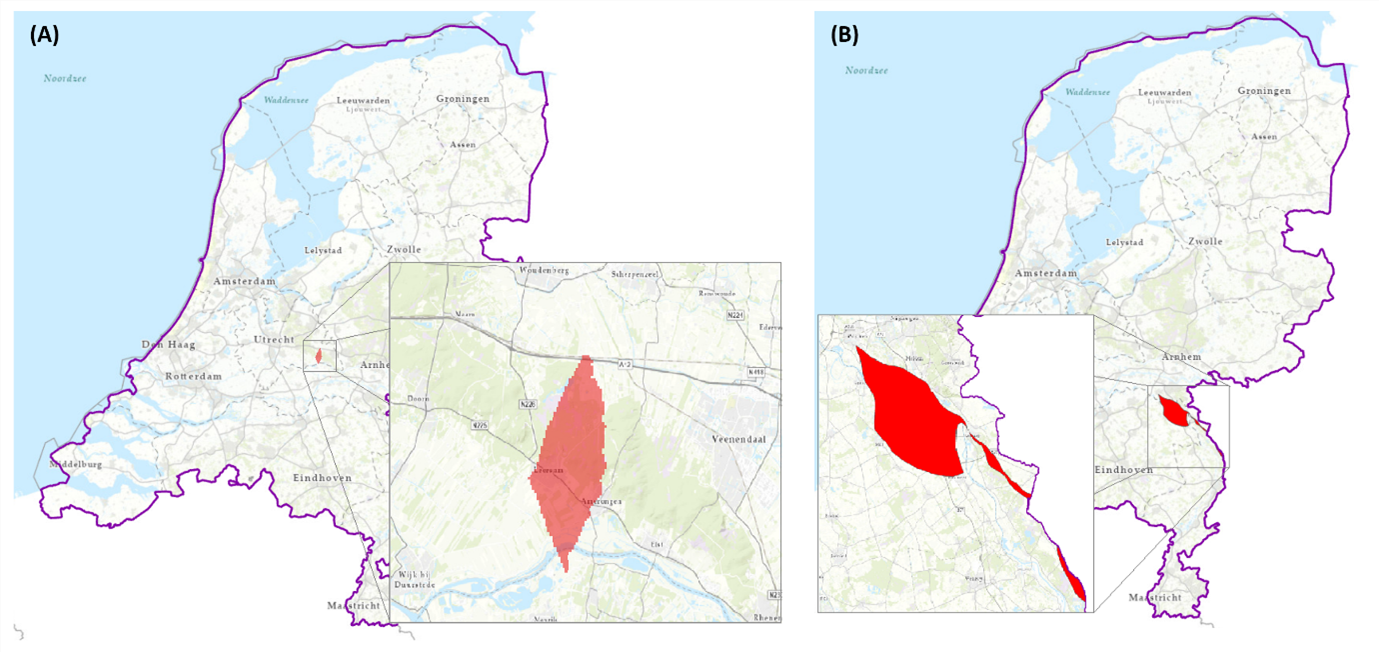 Figure 1 (A): The area where Oosterhout sand 1 and Oosterhout complex overlapped; (B) the area where the Kreftenheye sands 4 and 5 occured above the Beegden Formation. Outside these locations and in units other than those mentioned above, the model is remained unchanged.
Formation of Oosterhout
The first feedback concerns an inconsistency in the geometry of the hydrogeologic units Oosterhout sand 1 and Oosterhout complex in the southeastern part of the province of Utrecht (Figure 1A). Here, the top of Oosterhout complex intersects the base of Oosterhout sand 1, causing an erroneous overlap between these units. The base and thickness of Oosterhout sand 1 were corrected for this inconsistency. Subsequently, the parameterization of this sand layer (permeability and transmissivity) was also recalculated.
Formation of Kreftenheye
The second feedback concerns the numbering of the sand layers in the Formation of Kreftenheye in the southeast of the Netherlands where this formation occurs above the Formation of Beegden (Figure 1B). The sand layers here were incorrectly numbered as Kreftenheye sand 4 and Kreftenheye sand 5, whereas these sand layers can only occur below the Formation of Beegden. The sand layer numbering was corrected by removing the sand layers from Kreftenheye sand 4 and Kreftenheye sand 5 and adding them to the upper Kreftenheye sand 2 and Kreftenheye sand 3. All grid files of the sand layers concerned (2, 3, 4, and 5) were updated, including the grids showing permeability and transmissivity.
What did not change?
The model remained unchanged outside the areas shown in Figure 1. Within these areas, only the sand layers mentioned above have been modified. Thus, the resistant layers (“clay layers”) in the Oosterhout and Kreftenheye formations have remained unchanged in this release.
Want to know more?
The report Totstandkomingsrapport Kleine Release REGIS II v2.2.2 (PDF in Dutch 0.85 Mb) describes in detail the two feedbacks and solutions. This report is included in the model download together with the document Kwaliteitstoetsingsdocument (PDF in Dutch 0.69 Mb) which describes the Quality Control of this release. Further information on REGIS II can be found on the explanatory page of DINOloket.